Drone Surveys for Local Authority Asset Management
Smarter Infrastructure Oversight for Smarter Communities
Digital Asset Solutions partners with local authorities and councils to deliver high-resolution aerial inspections that streamline the maintenance and oversight of public infrastructure. From civic buildings to community facilities and transport assets, our drones provide a safe, efficient, and scalable solution to manage your public assets proactively.
Applications for Local Government

Building Condition Surveys
Inspect roofs, towers, and façades of schools, libraries, council offices, and leisure centres.
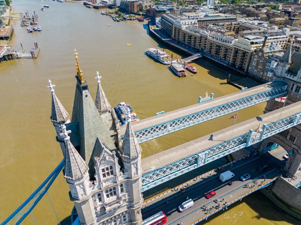
Transport & Infrastructure Monitoring
Assess bridges, car parks, bus stations, and road networks for structural health or environmental impact.

Land & Urban Planning Support
Capture accurate site data for planning, regeneration, and development proposals.
Environmental Surveys
Monitor flood plains, erosion, or green infrastructure with drone-based aerial mapping.

Why Local Authorities Choose Us
- Reduced Inspection Costs - Avoid costly scaffolding, road closures, or manual surveys.
- Evidence-Based Decision Making - Visual and data-rich reports that support funding applications or audit trails.
- Preventative Maintenance - Early issue detection means fewer emergency repairs and lower lifecycle costs.
- Geospatial Reporting - Every image and video is geo-tagged for precise location reference.
We work with housing departments, asset managers, regeneration teams, and facilities staff to help them do more — faster, safer, and smarter.
Contact us today to schedule a free consultation or demonstration about how our drone services can enhance your asset management strategy.
F.A.Q.
Here are some questions we usually get from our Corporate Real Estate Drone Inspection clients. If you can't find the answer to what you are looking for, do not hesitate to get in touch with us.
How can local authorities benefit from drone surveys in asset management?
Drone surveys allow councils to rapidly inspect public assets such as buildings, roads, parks, flood defences, and infrastructure. They reduce inspection costs, improve safety by limiting the need for working at height, and provide highly detailed data for proactive maintenance, budgeting, and risk management.
What types of local authority assets are suitable for drone surveys?
Drones can be used across a wide range of assets, including schools, libraries, council offices, leisure centres, car parks, bridges, highways, coastal defences, flood plains, parks, cemeteries, and housing stock. They are particularly useful for monitoring hard-to-reach or high-risk structures.
How accurate and reliable is drone survey data for council decision-making?
Modern drone surveys offer centimetre-level accuracy using high-resolution imaging, LiDAR, and photogrammetry. The data can be integrated into GIS systems, asset registers, and digital twins, providing reliable evidence for long-term maintenance planning, grant applications, and compliance reporting.
Are drone operations compliant with public safety and aviation regulations?
Yes. Professional drone operators hold Civil Aviation Authority (CAA) certification and follow strict flight safety protocols. Surveys are conducted with public safety in mind, ensuring minimal disruption to services while remaining fully compliant with regulatory requirements.
Can drone surveys help local authorities reduce long-term maintenance costs?
Absolutely. Early detection of defects such as roof damage, subsidence, or structural issues allows councils to address problems before they escalate. This proactive approach reduces emergency repairs, extends asset life, and supports more accurate capital investment planning.